Translate

Saturday, May 30, 2015

EARNING ITS KEEP ~ just business as usual for State Forestry unit 8-5 

State_DCR Fire District 8's 1964 Dodge Power Wagon hard at work at the May 22 Leominster fire on city conservation land:

The DEVIL'S PULPIT FIRE located on city watershed property burned 28 acres over several days before containment.  Accessible only by foot or ATV, state firefighters set up the Otter River State Forest based forestry unit (8-5) at the Fall Brook Reservoir.  

8-5 supplied water to crews manning 3 separate hose lines with a 4th line used to fill local units and ATV/UTV  tanks.  

Pumps on the Unit used on this fire:  

BB4 used to feed 2 hose lines (1.5" and a 1") laid into the fire; 
Mark III pump fed hose line to another section of the fire;  
Floto pump used for 8-5 tank feed (bypassing a temporary drafting issue); line acting as a relief valve back to the reservoir and a line to fill local units and ATV/UTVs


Friday, May 29, 2015

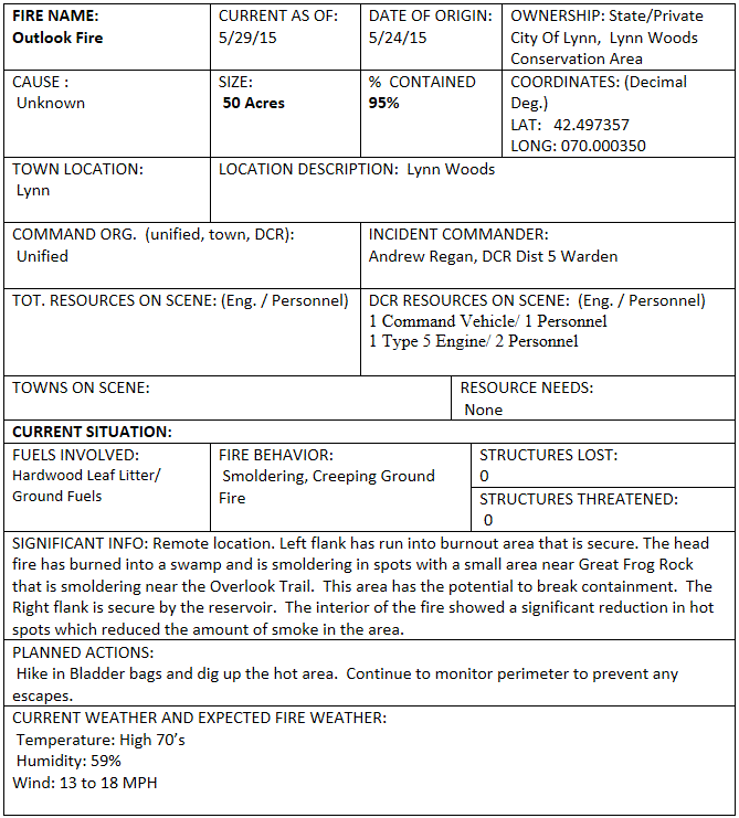
OUTLOOK FIRE ~ LYNN WOODS ~ Conservation Area ~ Lynn   May 29 update
Final update unless significant events warrant

fire is now in monitor status 

DCR District 5 Warden out of Bradley Palmer State Park reports the fire is at 95% containment until it is determined that the perimeter is totally secure from any potential escape


total acreage is mapped at 50 acres and not expected to change

kudos to MA_DCR  District 5 wildfire personnel for their innovative approach while assisting the Lynn Fire Department with management of this fire by bringing containment without taxing resources, damaging equipment, or compromising firefighter safety as they worked toward suppression completion


Wednesday, May 27, 2015

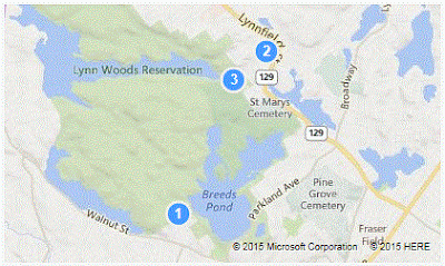
OUTLOOK FIRE / LYNN WOODS / LYNN update May 26 
  • Lynn Fire Department 
  • remote fire in the Lynn Woods Conservation Area
  • Because of difficult access and no values at risk, strategy has been to monitor the fire and allow it to burn out to a previously burned area, water and a fire access road
  • DCR is assisting with monitoring and advising

HEMENWAY HILL FIRE  / Milton
Blue Hills Reservation  -  May 26 update


  • Burnout operation on Monday has held the fire in place along existing trails along the south, west and north flanks of the fire.  
  • Aggressive mop up has eliminated most of the heat in the northeast corner, north of the Skyline trail.  
  • Fire behavior is now minimal smoldering interior.  
  • Fire will be monitored for the next several days. 
  • Final update unless significant events warrant. 

    for more about the Blue Hills Reservation  


Tuesday, May 26, 2015

FOLKS ... it really is dry out there ... please ...


Monday, May 25, 2015

SAUGUS RIVER TRAIL FIRE   May 25

All fires on state land are being held in monitor/patrol status for a few days to make sure perimeter's are secure given very low surface fuel moistures and increasing drought conditions in organic soil layers.


HEMENWAY HILLS FIRE May 25th update

Fire activity remained active again today with moderate wind gusts developing over the fire by mid morning. 
  • A change in strategy helped slow fire growth and increase containment after todays operational period. 
  • Crews from District 4, 1, and 3 conducted a burn out operation, which anchored the north and west flanks of the fire to Eustias Trail.  
  • A sawyer was ordered from Forestry to mitigate a number of burning dead trees, which were the source of embers and spot fires that compromised containment efforts. 
  • The fire remains actively smoldering on the interior and burning moderately deep in upper soil layers.  
  • Containment increased to 60%. 
  • Updated map will be available tomorrow.


MAY 24 - FIRES  2301 hour update


Sunday, May 24, 2015

May 24 HEMENWAY HILL - MILTON  2130 hour update

  • The fire continued to actively burn today along the northern perimeter as a period of gusty winds combined with high temperatures and low humidity settled in on the region.  
  • Short range spotting over containment lines in extremely dry light surface fuels impeded efforts to increase containment during todays operational period.  
  • The fire saw slow to moderate growth during the wind event today, increasing to approximately 21 acres by end of day.  
  • Crews are currently reassessing the strategy, making adjustment for the increasing moderate drought conditions in the fuel type, including use of existing trail infrastructure to the north and east as holding points to achieve containment.  
  • Fire is burning in a remote area of the reservation with no immediate values at risk.


... HEMENWAY HILL FIRE - 1730 hour update

  • The Hemenway Fire is within the Blue Hills Reservation and located approximately 1/2 mile northwest of the State Police Barracks at Houghton's Pond and along the Sky Line Trail.  
  • The fire is currently 12 acres with slow to moderate growth expected along the northern perimeter due to very dry fuel conditions in rugged terrain.  
  • Fire behavior has been active surface fire in surface leaf litter and some standing dead fuels with moderate burning into the dry upper soil layers, making full containment a challenge. 
  • Short range spotting over the line has occurred due to low relative humidity and very low fine fuel moistures in fuels up to 3" in diameter.  
  • Multiple local fire departments along with DCR Fire and Rangers are engaged on the fire and planning for multiple operational periods to achieve full containment in the next few days.


FIRE SITUATION BRIEFING -  May 24th - 1200 hours

Summary:  DCR Fire has been prioritizing and providing fire response assistance to a number of communities over the last 3 days.Most activity has occurred in the 
eastern, 
northeastern, and 
central interior portions of the state.  
    
      Fire activity increased over the last 2 days due to 
another influx of dry air bringing warm temps, 
low relative humidity values and 
gusty northwest winds. 
    
     Full green up of the forest canopy helped moderate fire spread by providing shading     
        to the surface fuels, however a serious rainfall deficit and very low fuel moistures   
        continue to render leaf litter and light dead fuels easily combustible. 
    
     Moderate drought conditions are now causing fires to burn into the organic soil 
         layers, making full containment more challenging.  
   
   DCR Fire Towers continue to play a pivotal role in spotting fires early, enabling
         town fire departments to catch most fires while they are manageable. 
    
To Date Mass DCR has logged 920 fires and 1,375 acres burned in 2015. 

Active Fires in the last 24 hours:
Northbridge  3      acres contained DCR assist
Northboro


Ludlow / Watershed land 13     acres contained DCR assist
Hemenway Hill, 
Blue Hills Reservation
     map below
12     acres contained / 40% DCR on scene
Lincoln / Sandy Pond Fire 12.3  acres contained / 40% /active DCR on scene
Leominster / watershed land 30     acres active 2 Task Forces, DCR on scene
Gloucester 8- 10 acres

DCR on scene; no new info


Saturday, May 23, 2015

HEMENWAY FIRE - MILTON, MASSACHUSETTS   1900 / May 23rd - Update
  • within the Blue Hills Reservation 
  • located approximately 1/2 mile NW of the State Police Barracks at Houghton’s Pond and along the Sky Line Trail
  • fire is currently 12 acres
  • slow to moderate growth expected along the northern perimeter due to very dry fuel conditions in rugged terrain  
  • Fire Behavior has been active surface fire in surface leaf litter and some standing dead fuels with moderate burning into the dry upper soil layers, making full containment a challenge 
  • short range spotting over the line has occu days rred due to low RH and very low fine fuel moistures in fuels up to 3" in diameter
  • multiple local fire departments along with STATE_DCR Fire and Rangers are engaged on the fire and planning for multiple operational periods to achieve full containment in the next few days 


    Friday, May 22, 2015

    May 21, 2015  Prescribed Fire / Mass Division of Fish and Wildlife's managed area /Falmouth


    Wednesday, May 20, 2015

    Did'ja Know? ...  
                       that the Manuel F. Correllus State Forest on Martha's Vineyard, once was home to 
                             the last surviving Heath Hen ...

    Now extinct, but then strutting through the brush, male Heath Hens boomed and pounded the earth to attract a mate.  Each year, returning to their breeding grounds, they engaged in spectacular displays of bravado and strength, jumping and spinning in the air, thrusting their chests against one another, as they competed for the right to propagate their species.  

    When European settlers arrived on the east coast, they hunted the bird so extensively that servants bargained not to be fed Heath Hens more than two or three times a week.  The Heath Hen's habitat stretched along the coast of New England from Maine to Virginia.  but by 1870, due to overexploitation, the Heath Hen population on the mainland of the east coast had vanished.  

    Numbering in the 100's, the survivors lived on Martha's Vineyard.  Over the next quarter of a century, the state of Massachusetts attempted to save them:  enacting a hunting ban, shooting predatory animals, planting crops to feed the hens, and establishing a 'heath hen reserve' (now the Manuel F. Correllus State Forest)  in 1908. But numbers continued to diminish. A disastrous fire, an unusually harsh winter,  the unfortunate arrival of goshawks, a serious Heath Hen predator, and a poultry disease ravaged the remaining population.

    Heath hens usually flew only to the lower branches of trees.  But in 1929 ornithologists witnessed a hopeful male (named Booming Ben) fly to the top of a tree and call out loud and repeatedly across the island.  There were no Heath Hens to hear his pleas.  He was last seen on March 11, 1932.

    essay by Todd McGrain / Lost Bird Project  (repeated here mostly in its entirety with a few informational items taken from other documentation)


    SPECIAL WEATHER STATEMENT ~ NWS     
    
    NATIONAL WEATHER SERVICE TAUNTON MA
    412 AM EDT WED MAY 20 2015
    
    ...ELEVATED FIRE WEATHER RISK ACROSS MASSACHUSETTS TODAY...
    
    A DRY AIRMASS WILL OVERSPREAD THE REGION TODAY ALONG WITH GUSTY
    NORTHWEST WINDS OF 15 TO 25 MPH. THIS WILL RESULT IN MINIMUM
    RELATIVE HUMIDITIES BETWEEN 30 TO 35 PERCENT ACROSS
    MASSACHUSETTS.
    
    DESPITE YESTERDAY/S SHOWERS GUSTY NORTHWEST WINDS TODAY COMBINED
    WITH A VERY DRY AIRMASS WILL RAPIDLY DRY OUT ANY RESIDUAL TOP
    LAYER GROUND MOISTURE. AS SUCH LOCAL FIRE WEATHER OFFICIALS HAVE
    ADVISED OF AN ELEVATED FIRE SPREAD POTENTIAL DUE TO THE DRY AND
    WINDY CONDITIONS FORECAST TODAY.
    http://1.usa.gov/KMb6Fm

    Tuesday, May 19, 2015

    MASSACHUSETTS: Wildland Fire Assistance available

    The Volunteer Fire Assistance grant round is open to eligible communities meeting requirements.  Applications are due back to DCR by June 12 for award consideration.

    These grants are available to non-profit rural call or volunteer fire departments that primarily serve a community or city with a population of less than 10,000. The fire department must be made up of at least eighty percent (80%) call or volunteer firefighters, be recognized as a department under state law and be National Incident Management System compliant.

    The VFA grant applications must be completed in full and received before June 12, 2015 to be considered for an award. Please submit your VFA grant application to:
    DCR Bureaus of Forest Fire Control and Forestry
    Attn. Roxanne B. Savoie
    Hampton Ponds State Park
    1048 North Road/Route 202
    Westfield, MA 01085

    Application Materials: 2015 VFA Application 

    May 19 - possible thunderstorms later today;
    FIRE WEATHER PLANNING FORECAST FOR SOUTHERN NEW ENGLAND
    NATIONAL WEATHER SERVICE TAUNTON MA
    440 AM EDT TUE MAY 19 2015
    
    .DISCUSSION...
    
    RAIN WITH EMBEDDED HEAVIER SHOWERS WILL BE THE STORY THIS MORNING CONTINUING EAST THROUGH AFTERNOON. THIS WILL  ALLOW AREAS ACROSS THE WEST TO CLEAR OUT YIELDING THE LIKELIHOOD FOR REDEVELOPMENT OF SHOWERS AND THUNDERSTORMS ... SOME OF WHICH MAY BE STRONG TO PERHAPS MARGINALLY SEVERE WITH THE MAIN THREAT BEING VERY LOCALIZED STRONG TO DAMAGING WIND GUSTS WITH HAIL A SECONDARY CONCERN.
    
    WET WEATHER ACTIVITY CONTINUES INTO THE OVERNIGHT HOURS. COULD BE LOOKING AT AN AVERAGE OF0.25-INCHES OF TOTAL  RAINFALL OVER SOUTHERN NEW ENGLAND.


    Monday, May 18, 2015

    No Measurable Rainfall in over a Month ~ May 19 
    Year to date totals:  920 fires have burned 1,375.85 acres; Massachusetts will welcome rain forecasted for Monday night through Tuesday - no measurable rain has fallen for over a month
    May 3, 2015   Clarksburg SF 90% containment;


    May 2, 2015   Clarksburg SF 10:12am update; 85% containment; DCR State/Local MA & VT firefighters on 272 acre fire;


    April 19, 2015  West Tisbury, Martha's Vineyard;

    April 19, 2015   West Tisbury, Martha's Vineyard;
    April 19, 2015   Please be careful with ALL fire!


    April 15, 2015  EA Predictive Service videocast 1.usa.gov/1aVMze7 Elevated Fire Potential Exists